I’m in agreement with Timothy B. Lee’s posts a month ago that urban freeways are not needed and harmful, but whether any particular urban freeway ought be actively taken down depends. (Of course no more ought be built and nearly all existing ought not to have been built.)
Lee’s posts got me thinking about which of Oakland’s freeways ought be torn down first.
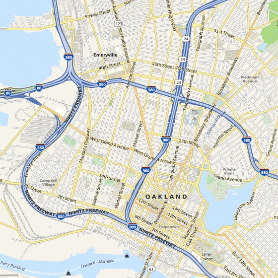
The map above gives a pretty good idea of Oakland freeways. Clockwise from the top there’s 80/580 going north into Berkeley, 24 into a tunnel through the hills, 580 and 880 continuing on for a long way to the southeast and into San Leandro (there’s also 13 in the hills connecting 24 and 580, the only segment completely off-map), and 80 across the bay to San Francisco. Then there’s 980 connecting 24 and 880. 980 is the obvious segment to go:
- Traffic volumes on 980 are less than any of the others (excepting 13).
- 980 cuts West Oakland off from downtown, and causes the former to be completely encircled by freeways.
- Despite being relatively low traffic, the real estate used by 980 is a city block wide. About 29 core city blocks could be freed for other uses.
- 980’s primary purpose is apparently for providing access to downtown Oakland. A freeway through downtown is not needed for downtown access. Drivers wanting downtown access need to drive on downtown streets, and can do so just a tiny bit sooner. Downtown Oakland streets have lots of capacity and are rarely congested.
- In the next decades, autonomous vehicles will push “not needed” to the extreme, as such will enable much, much higher capacity on the same roads. Oakland, like all cities, ought to be planning for autonomous vehicles now.
Before last month, I had not realized that 980 was not completed until 1985, which by itself does not strongly support my understanding of the local narrative (which I must have heard by 1995) concerning the extent to which 980 negatively impacted West Oakland. But apparently construction started in 1964. Planning was underway in the 1950s. I’m don’t know when about 29 blocks were destroyed to make way for 980 (I’d appreciate pointers), but it could have been 20 or more years before completion, and even if not, the knowledge that they would be destroyed must have contributed to isolation.
Perhaps Occupy Oakland ought move to some of the greenery along 980, or Grove-Shafter Park, which is more or less under the interchange where 24, 580, and 980 meet — more than symbolic, a physical barrier separating the poor from the powers that be. They wouldn’t need to make any specific demands about what would come after destroying the segment of the system that is 980. 29 blocks of vertical hemp farms? Mixed income housing? Art studios? “Occupy Park”, a grand urban park named for the movement? Skyscrapers? Ironically nostalgic monorail line? No need to decide now, dream on!
[…] Addendum: Now you know why I didn’t include a stadium in my fanciful list of uses Oakland residents ought dream for land recovered through demolishing highway 980. […]
That map looks like an OpenStreetMap, but no attribution. Please add it.
[…] commenter called me on providing inadequate credit for an map image I used on this blog. I’ve often seen map […]
Chris, the image links directly to where I copied it form http://www.openstreetmap.org/?lat=37.8134&lon=-122.2776&zoom=14&layers=Q but you’re right, I hadn’t complied with http://www.openstreetmap.org/copyright
I happened to know what you were talking about, but I hope people include http://www.openstreetmap.org/copyright when asking random people to provide attribution to OSM so that they know exactly what to do.
Thanks for the comment. Fixed the attribution and license notice, and blogged about the implementation at http://gondwanaland.com/mlog/2012/01/08/css-text-overlay-attribution/
[…] reconfigure cities, not least by vastly reducing the amount of space needed for cars. There are a couple obvious ways to get started in that direction now. Whether a city makes good on this opportunity […]
Some discussion over past months at https://neighborland.com/ideas/oak-to-remove-highway-980-wh
To read:
* http://www.cnu.org/highways
* https://en.wikipedia.org/wiki/Freeway_removal
[…] continued semi-dense infill development, and plausible recovery of lots of space for people via freeway demolition and robot cars, they would continue to be […]
[…] case that the Bay Area doesn’t need the 980, the most underutilized freeway in the region. Linksvayer’s post, Occupy 980, inspired me to think more about the many ways the 980 corridor could be transformed into something […]
[…] Saturday, July 12, there’s a big open streets event in my obscure flats neighborhood where Oakland, Emeryville, and Berkeley meet. A small stretch of San Pablo Avenue will be closed to cars (sadly not only human-driven cars, which would momentarily meet my suggestion). There will be an Oakland Urban Paths walk in the neighborhood during the event, during which obscurities will be related. Usually these walks are in locations with more obvious scenery (hills/stairs) and historical landmarks; I’m looking forward to seeing how they address Golden Gate. Last month they walked between West Oakland and downtown, a historic and potentially beautiful route that currently crosses 980 twice — edit it out! […]
[…] issue I don’t think any candidate has […]
[…] field development. Don’t bet on retail or sports teams. Do eliminate gratis parking, remove 980, and otherwise prepare Oakland to exploit rather than be exploited by the great urban […]
[…] Avenue (there’s another to the south between Emeryville and downtown Oakland, passing under 980) has substantial and poorly maintained medians (weed control cloth which is exposed, tattered, and […]